top of page

Thru-Hiking the Chief Pontiac Trail, Pt. I: Highland to Proud Lake

From the heights of Mt. Omich to the lowlands of the Huron River, we retraced the generational footsteps of one of the Detroit region's oldest backpacking routes: the Chief Pontiac Trail. Join us on Part 1 of this series as we traverse this classic Michigan hiking trail from Highland to Proud Lake!

Chief Pontiac Trail michigan hiking backpacking boy scouts highland recreation area expedition detroit

"There's no way that it was like this in the 1950s."


I say those words audibly to myself as yet another set of headlights blind me along Wixom Trail. It's just past 10 p.m., and I've got the red light setting on my headlamp turned on to alert oncoming traffic that there is, in fact, a rouge vagabond backpacking along the side of a major road on a Friday night.


A few cars flash their headlights at me. Maybe they think that I'm lost. Or they're checking to confirm that an apparition of Chris McCandless hasn't returned to haunt the outskirts of Milford. Regardless, they're obviously - and understandably - confused at the spectacle in front of them.


Against all odds, however, I'm right where I'm supposed to be. Not arriving at the trailhead at 6:30 p.m. for a 10.5+ mile backpacking trek would've been ideal, but regardless of my tardy departure, I'm exactly on-trail for the first segment of the traditional Chief Pontiac Trail. A prestigious expeditions that generations of Boy Scouts have traversed since 1958, when these roads assuredly were sleepy, backcountry routes to the outskirts of a growing Oakland County.


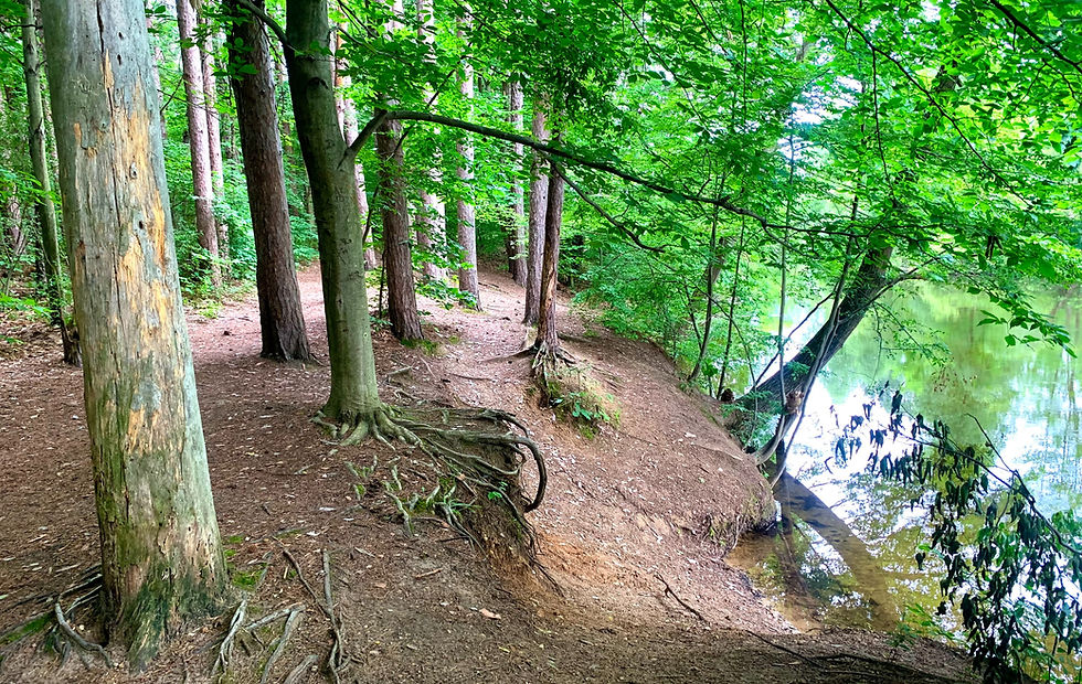
A welcomed sigh of relief hits my tired legs as I finally verge off of the main roads and back into the sanctuary of Proud Lake State Recreation Area. I have another 2.6 miles to go, but the familiar woods - even in the pitch dark - feel like home. A beautiful, natural environment that has hardly changed in the last 65 years thanks to ardent conservationism and prevailing common sense.


My calorie-deprived mind is complete mush at this point, but as I cross the Moss Dam Bridge I start to think about the trail that I'm following - and how it so accurately reflects the state of the Detroit region's outdoors. The grand history and decades-long visions that led to its establishment. The maintenance actions - or lack thereof - the led to its current state. The almost total lack of online visibility regarding its navigation and operation. And, most importantly, the opportunities for its future.


Out of all of our exploits on the Expedition Detroit platform, thru-hiking the Chief Pontiac Trail undoubtedly holds the title as our truest "expedition" to date. It's a rigorous, often overgrown, and occasionally unmarked trail that requires backpackers to stay dialed-in throughout the journey.


It's our great pleasure to introduce this quintessential trail to our audience now.

Chief Pontiac Trail michigan hiking backpacking boy scouts highland recreation area expedition detroit

MEET THE CHIEF PONTIAC TRAIL

In the mid-20th century, the state of the outdoors throughout North America - and especially in the Detroit region - was booming. As the assembly lines of Detroit's factories increasingly produced cars, Michigan's road networks expanded in stride across the heart of the region's growing metropolitan area. With these rapidly road networks and sprawling urbanization, Detroiters steadily found themselves craving newly-accessible outdoor escapes - including those previously owned by their employers.


Western Oakland County evolved into the destination of choice for such intrepid recreationists. Of the 10 "state recreation areas" established by the Michigan Department of Conservation in 1944, 6 reside within the county and 3 others immediately outside its confines (Island Lake, Brighton, and Metamora-Hadley Recreation Areas). Furthermore, two of the most accessible of these recreation areas - Highland and Proud Lake - were conveniently separated only by the growing community of the rural Village of Milford. These two recreation areas alone captured the best of southeast Michigan's pristine outdoors: wooded moraine highlands, dense hardwood forests, towering pines, wildlife-dense marshlands, and the stunning Huron River.


As you could imagine, it didn't take very long for the trail-building visionaries of the mid-20th century to dial in on these two recreation areas for a new backpacking route.


Although an original route omitted Highland from the Chief Pontiac Trail's itinerary, the trail officially opened on June 14, 1958. The genesis for the trail first originated with members of the Ottawa District of the Clinton Valley Council in 1957, although Boy Scouts of America Troop 108 of the Walled Lake Methodist Church adopted and completed the construction of the trail in Spring of 1958.


The Boy Scouts promoted the trail with a twofold purpose. The first and obvious aim included enabling Scouts to gain valuable lessons in physical endurance, backpacking, first aid, cooking, camping, map reading, compass use, and general safety while on-trail. Second, to foster a historical and cultural appreciation of the great Ottawa Chief Pontiac - the most formidable leader of the Great Lakes Native American resistance movement who governed over a confederacy of Chippewa, Potawatomi, Ojibway and Ottawa tribes. These core purposes are still reinforced today by the Chief Pontiac Trail Committee.


In 2023, Scouts can still earn special badges through a variety of Chief Pontiac Trail routes. These include special paddling, winter hiking, and a Highland-only loop routes. The route detailed in this two-part series follows a slightly-modified version of the "Conventional Hike" route - the 16.5 mile route that includes an overnight at the Pines Campground in Proud Lake.


We were unable to secure a campground at Pines, so our route - the "Expedition Detroit CPT Route" - involves a slightly-longer first segment to Proud Lake's Modern Campground. Sorry, Scouts, you will not earn a badge for completing this route of the Chief Pontiac Trail...yet.

CHIEF PONTIAC TRAIL: Highland Recreation Area to Proud Lake Modern Campground

Total Distance: 11.30 miles

Elevation Gain: 574 feet

Trail Rating: Moderate

Route Orientation: Point-to-Point

Parking Specifics: Parking available at Haven Hill Barn Parking Lot; Michigan Recreation Passport required.


Like several other of North America's greatest hikes, your adventure down the Chief Pontiac Trail starts with a slight backtrack. While the official trailhead parking lot is right beside the massive, white Haven Hill Barn, Trail Marker #1 for the Chief Pontiac Trail is actually located 0.1 miles due west towards Highland's "Youth Group Campground." I opted to leave my pack in the parking lot for this brief jog over to the official starting sign (see the cover photo for this article), and the blooming wildflowers alongside the trail made it a trek absolutely worth trekking. Great photo op by the sign as well before officially kicking off your thru-hike.

Chief Pontiac Trail michigan hiking backpacking boy scouts highland recreation area expedition detroit wildflowers

Once you're back at the parking lot, grab your pack, traverse the parking lot(s), and locate the unofficial trailhead at the far eastern edge. The Chief Pontiac Trail largely consists of an interconnected network of separate trails, with this initial 0.4 miles following Highland's "East Trail." As a word of precaution, look for an orange trail marker at the 0.3 trail marker to guide you WEST towards a noticeably rounded hill. Yeah...I missed that trail marker and ended up adding nearly a mile to an already long first segment. Don't be me.


You'll finally escape Highland's paved parking lots at the 0.6 mile marker (trail marker #28). From here, you will hike 0.6 miles along the southern edge of Highland's famous Haven Hill Natural Area, one of the crown jewels of the park. While the Chief Pontiac Trail omits the namesake Haven Hill climb from its itinerary, there is a decent 10% incline that hits at the 1 mile marker. For the most part, however, this section of the trail serves to warm up your legs with some oscillating climbs and falls, boardwalks and marsh vistas.


Two minor words of caution for this initial segment. First, bug spray - LOAD UP on it. Highland in the summer months is notorious for its mosquitos due to the park's multitude of ponds and kettle pools, so don't be stingy with your insect repellant. Second, you will be hiking along Highland's bridle trails during this portion of the Chief Pontiac Trail. Stated differently, mind your step - some stretches comprise of a horse poop minefield. Consider yourself warned.

Chief Pontiac Trail michigan hiking backpacking boy scouts highland recreation area expedition detroit tunnel road bridge

Starting at the 1.2 mile marker, you will start seeing signs for the "Tunnel Trail." This refers to the makeshift, graffiti-decorated tunnel that passes under Duck Lake Road and connects the "Haven Hill" zone of Highland to the "Mountain Bike Trails" zone. In full transparency, I had no idea that this tunnel existed - and I was really pumped to backpack through it. Trails are remembered and celebrated for little features like this, and I hope that Highland allocates some of its future budget towards converting this tunnel into a destination of sorts (e.g., the M-52 tunnel on the Waterloo-Pinckney Trail).


Once through the tunnel, you'll hike all of 0.2 miles before arriving at Highland's expansive Mountain Bike Trailhead. Friends, this is where the real fun begins. Over the next 2.6 miles, you will follow the Chief Pontiac Trail directly through the heart of Highland's famous - no, notorious - MTB trail system. Honored as the hardest of the Detroit region's three "Black Diamond Trails," Highland's A-B-C-D loops lead riders, trail runners, and hikers through a roller coast of steep climbs and technical turns.


The Chief Pontiac Trail, for better or for worse, largely steers clear of the most technical aspects of this landscape through its relatively straight north-south orientation. Don't think for a second, however, that this means that you will traverse through this rigorous landscape with ease. To the contrary, the trail leads hikers directly over the 1,139 ft. summit of Mount Omich, including a 12% incline, to reach the second-highest point in Highland Recreation Area. So yes, you will assuredly earn your passage through Highland's highlands.

Chief Pontiac Trail michigan hiking backpacking boy scouts highland recreation area expedition detroit

Your expedition through Highland ends within a series of wildflower fields before reaching the Barn Course Field Trial Grounds. If you're following the Expedition Detroit route, then the shelters, restrooms, and water pump found here provide an ideal spot to rest, have lunch, and gear up from the traverse waiting for you. I was fighting daylight by this point, so unfortunately I just topped off my water bottle at the pump and kept pushing forward. However, if you do have 30 mins or so to rest, please take it. Your legs will thank you in a few short hours' time.


Following a short eastern jog down Cooley Lake Rd., you will turn due south on Burns Rd. at the 5 mile marker. Guys, there's no way to sugar coat this: 3.7 miles of hiking alongside main roads totally sucks. The country-style Burns Rd. portions aren't terrible - actually had some of my best wildlife viewing opportunities while hiking down Burns - but the Commerce St. crossing, Wixom Trl, and Sleeth Rd. portions are brutal. Even more so, they're unnerving. Switching from the solitude of Highland to the headlights of main roads is simply jarring to the senses.

ROAD HIKING 101

We briefly interrupt this article for a quick crash-course on road hiking etiquette. As much as we'd love for all of our trails to solely exist in untamed wilderness, alas, we live amidst a modern and intrusive society. Several of North America's largest and most celebrated trails - include the North Country Trail and Appalachian Trail - have road-hiking portions. The Chief Pontiac Trail is no different, and while road portions of trails serve to efficiently connect one natural area to another, they pose a certain amount of inherent risks.


Here's a cheatsheet on maximizing your safety while traversing road sections of scenic trails:

  • ALWAYS HIKE AGAINST TRAFFIC (i.e., along the left side of the road).

  • HIKE AS FAR AWAY FROM THE ROAD as reasonably safe and without trespassing.

  • ERR ON THE SIDE OF CAUTION when crossing roads.

  • IF IN A GROUP, hike in a single file line.

  • NEVER WEAR HEADPHONES while hiking along main roads.

  • AT NIGHT, wear reflective clothing and/or keep your headlamp on its red light setting.

Stay safe out there. Now, back to the Chief Pontiac Trail.

Chief Pontiac Trail proud lake state recreation area michigan hiking backpacking expedition detroit moss dam bridge
Photo courtesy of Tripadvisor LLC

At the 8.7 mile marker on Sleeth Rd., your eyes finally locate the sight that they've so desperately sought after: the painted sign for the Walled Lake Outdoor Education Center. This sign means a relief from the monotony of road hiking, noise pollution of car traffic, and a return to the wild. You will still need to walk 0.3 miles to reach the northern boundary of Proud Lake State Recreation Area, which is directly accessible from the Center, but there are ample benches within the Center's grounds for resting your legs. Trust me, you'll greatly appreciate them.


Follow the paved bike path near the Center's southeast corner until you see a large brown sign demarcating the resumption of the natural Chief Pontiac Trail. The trail starts up again with a sharp descent before flattening out alongside the marshes of the Huron River. You will reach one of the lowest points of the entire Chief Pontiac Trail while crossing the boardwalks leading up to the Moss Lake Dam Bridge - a 234 ft. elevation difference from your highest point just hours before.


Once across the bridge, the next mile of Proud Lake hiking provides a highlight reel sprint of some of the park's most beloved trails. Following the Orange Trail from the bridge, you will traverse the northern stretches of the Proud Lake's expansive marsh ecosystem until reaching the aptly-named Marsh Trail at mile marker 9.9. Continue south as you hike around the far eastern bank of Proud Lake's very scenic marsh. You may find yourself tempted to continue your circumnavigation of the marsh, but our route stays south towards Trail Marker #6.

We're closing out this narrative on the Chief Pontiac Trail with good news and bad news. Starting with the good, Trail Marker #6 designates that the end is near for Day 1 on the trail. All that remains in front of you is an eastward two-track trail that dead ends at Proud Lake's Modern Campground. The bad news is that you have 0.9 miles before reaching it. That mileage may not sound like a lot while reading it within an article, but your legs will likely beg you to simply pull off the trail and set up camp in the woods during this stretch. Or at least mine were.


Push through though, dear hiker - a modern campground stocked with remedying amenities awaits you.


We would like to end this article with a suggestion for the Chief Pontiac Trail Committee, Boy Scouts of America, or really any interested trail advocacy group to consider. That suggestion is a route re-navigation through Downtown Milford. Here are our reasons why:

  • Safety. Hiking alongside Wixom Trail and Sleeth Road may have constituted leisurely country road hiking in the mid-20th century, but with the growth of Milford and Commerce Townships of the last 30 years, this route now seems unnecessarily dangerous. I could not imagine leading a crew of teenagers along this route without having at least 3 anxiety attacks.

  • Viable Alternative Routes. As demonstrated by the Milford Bike Fest's "Century Challenge," other safe, scenic, and trail user-friendly routes exist through the Milford area. Within Highland, there's an opportunity to turn southwest at the 4.5 mile marker to connect to the Milford Connector Trail - a relatively new trail that safely guides bikers and hikers to Highland's southernmost section. The Milford Connector Trail ends at scenic Weaver Rd., which further leads hikers into the heart of Downtown Milford. Main Street in Milford then connects directly to Oakland Street/Garden Road, including this route's scenic vistas along the Huron River, historic Oak Grove Cemetery, and eventually Proud Lake State Recreation Area. Yes, hikers will miss Moss Lake Dam Bridge, but (a) the following day's route could backtrack slightly to include such highlights and (b) HIKERS WILL FEEL SAFE THROUGHOUT THEIR JOURNEY.

  • Trail Town Benefits. Trail towns are an integral component to any world-class thru-hiking experience. Despite that fact, the classic Chief Pontiac Trail appears to go well out of its way to avoid the immaculate, celebrated trail town that is Downtown Milford. Backpackers would even have the opportunity to restock their supplies at Blue Birch Outfitters, one of our favorite #ExpeditionPartners and a gear sponsor for this thru-hike.


We'd like to offer a special thank you to Blue Birch Outfitters for addressing our gear needs and outfitting us with a brand new Osprey backpack for this adventure! Hitting the trail with the right gear can truly make or break an outdoor experience. With Blue Birch's convenient location in the heart of Downtown Milford, you can explore the vast majority of the Detroit region's outdoor destinations knowing that there's a fully-stocked retailer just around the corner.

bottom of page